Madrid Tourist Map: City Center, Metro, Museums and Routes
We are Ana and Kevin, and Madrid is much easier when you read the city by zones. The historic center, Royal Palace, Plaza Mayor, Puerta del Sol, Gran Via, Prado, Retiro and neighborhood areas all sit close enough to combine, but the best route depends on how much walking you want and when you use the metro. This Madrid tourist map helps you plan a practical city center route instead of jumping randomly between sights.
Disclosure: this article contains affiliate links. We may earn a commission if you book accommodation, activities, insurance or flights through them, at no extra cost to you.
If you are searching for a map of Madrid, tourist map of Madrid, Madrid city centre map or Madrid metro map, start by separating sightseeing from transport. The metro is excellent for longer jumps, but the core tourist route is best planned on foot. For a wider Spain route, compare this page with our Spain tourist map, Seville tourist map and north of Spain map.
Interactive Tourist Map of Madrid
Use the map to group the Royal Palace and historic center, Gran Via and Puerta del Sol, the museum district, Retiro and practical stay areas. Madrid rewards walking, but the metro helps when you cross from one side of the map to another.
Load the Madrid map to group the historic center, museum district, Gran Via, Retiro, metro-friendly routes and hotel bases.
Open the Madrid tourist map in Google MapsBest Areas to Read on the Madrid Map
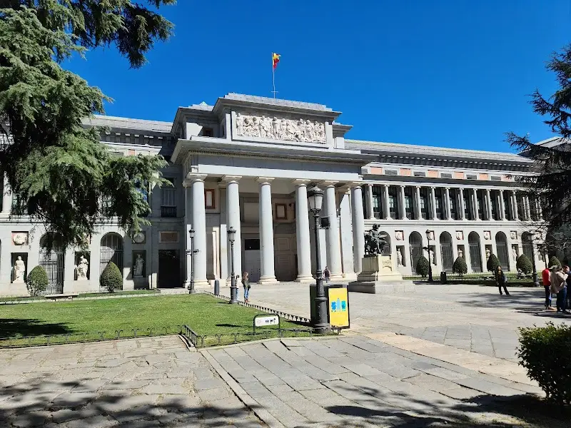
Royal Palace, Almudena and the historic center
The Royal Palace area is a strong first anchor because it connects easily with Almudena Cathedral, Plaza de Oriente, Plaza Mayor and Puerta del Sol. This is the route we would use for a first morning in Madrid.

Puerta del Sol, Plaza Mayor and Gran Via
Sol and Plaza Mayor form the classic central Madrid map section, while Gran Via adds theatres, shopping, hotels and access toward Chueca and Malasana. This area is busy, but it is practical for orientation and short stays.
Prado, Retiro and the museum district
The museum district needs slower planning. Prado, Thyssen, Reina Sofia, Retiro and the Palacio de Cristal are close on the map, but trying to visit every museum deeply in one day is too much. Choose one main museum and leave time for Retiro.

Metro-friendly neighborhoods
La Latina, Chueca, Malasana, Salamanca and Atocha can all work depending on your style. Use the metro for longer jumps, but keep each day centered on one side of the map so you do not spend the trip underground.
Suggested Madrid Routes from the Map
Classic half day: Royal Palace, Almudena, Plaza Mayor, Puerta del Sol and Gran Via.
Museum and park day: Prado or Reina Sofia, Paseo del Prado, Retiro and Palacio de Cristal.
Food and neighborhoods: La Latina, Mercado de San Miguel, Plaza Mayor, Chueca or Malasana depending on your evening plan.
Two-day Madrid route: historic center on day one, museum district and Retiro on day two, with metro jumps only when they save real time.
Where to Stay in Madrid for Easy Map Routes
For a first visit, compare Sol/Gran Via, Plaza Mayor/La Latina, Retiro/Prado, Chueca/Malasana and Atocha. Sol is central, Atocha helps with trains and museums, Retiro feels calmer, and Chueca or Malasana are stronger for food and evenings.
Plan activities, insurance and flights for Madrid
Once the map route is clear, the next practical step is checking what to book around it: guided activities, travel insurance and flight options if you are coming from abroad.
Use the activity widget below to compare current tours and tickets for Madrid. For the travel side, you can also review insurance with IATI and compare flights before fixing dates.
Madrid Map Planning Checklist
Best first anchor: Royal Palace and Plaza Mayor for the historic center.
Best transport rule: walk the central route; use the metro for cross-city jumps or tired legs.
Best museum decision: choose one major museum per day if you want to enjoy it properly.
Best mistake to avoid: planning Madrid only by distance. Crowds, museum time and meal breaks change the route.
If you want a nature-and-villages escape from Madrid, compare your city plan with our La Vera tourist map.
Frequently Asked Questions about the Madrid Tourist Map
What should be on a Madrid tourist map?
A useful Madrid tourist map should include the Royal Palace, Plaza Mayor, Puerta del Sol, Gran Via, Prado, Retiro, Atocha, La Latina, Chueca, Malasana and metro-friendly stay areas.
Is Madrid easy to visit on foot?
Yes. The historic center and museum district are very walkable. The metro is best for longer jumps, airport connections and crossing between neighborhoods.
Where should you stay in Madrid for sightseeing?
Sol/Gran Via is most central, Atocha is practical for trains and museums, Retiro is calmer, and Chueca or Malasana work well for food and evening plans.
Do you need a Madrid metro map?
Yes, but use it as a transport layer, not as the whole itinerary. Plan your sightseeing route first, then use metro stops to reduce long transfers.