

Vietnam Tourist Map: Cities, Bays and Travel Routes
We are Ana and Kevin, and Vietnam is one of those countries where the map matters before the itinerary. The country is long and narrow, so a good Vietnam tourist map helps you decide whether to travel north to south, focus on one region or connect flights, trains and road sections. Hanoi, Ha Long Bay, Ninh Binh, Hoi An, Da Nang, Ho Chi Minh City, the Mekong Delta and the islands all need a different rhythm.
Disclosure: this article contains affiliate links. We may earn a commission if you book accommodation, activities, insurance or flights through them, at no extra cost to you.
If you are comparing a Vietnam tourist map, map of Vietnam, Vietnam travel map or Vietnam route map, start by choosing the length of the trip. For a wider Asia plan, compare this page with our tourist map of Thailand, tourist map of China and tourist map of Hong Kong.
Interactive Vietnam Tourist Map
The interactive map helps you group the country into practical travel areas: northern Vietnam, Ha Long Bay and Ninh Binh, central Vietnam, Ho Chi Minh City, the Mekong Delta and beach or island stops. Vietnam looks simple as a north-south line, but travel time changes quickly depending on trains, domestic flights and overnight buses.
Use this interactive tourist map of Vietnam to explore the main attractions, routes, viewpoints and practical planning areas.
Open the Vietnam tourist map in Google MapsBest Areas to Read on the Vietnam Map
Hanoi and northern Vietnam
Hanoi is the natural starting point for many Vietnam routes. Use it as a base for the Old Quarter, lakes, food streets and day or overnight trips. If you want mountains, rice terraces and dramatic roads, our tourist map of Ha Giang Vietnam and tourist map of North of Vietnam help narrow the northern section.
Ha Long Bay, Lan Ha Bay and Ninh Binh
This is the classic nature block near Hanoi. Ha Long or Lan Ha Bay works for limestone islands and boat routes, while Ninh Binh gives you rivers, viewpoints, temples and countryside. We would not treat both as quick checkmarks. Give each one enough time or choose the one that fits your route better. For more detail, see our Ninh Binh tourist map.


Central Vietnam: Hue, Da Nang and Hoi An
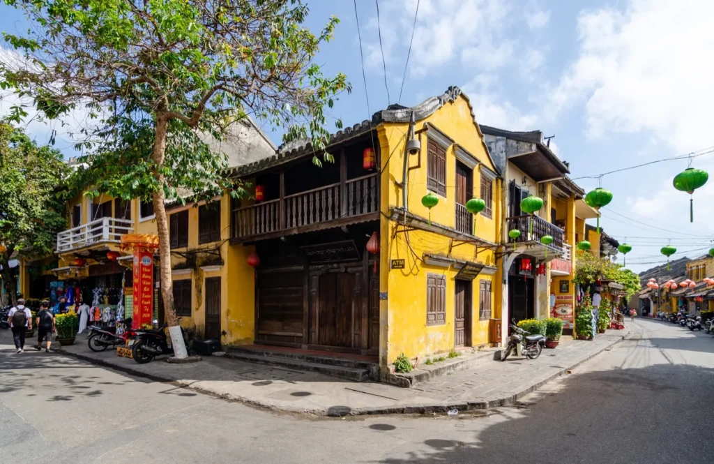
Central Vietnam is the map section where history, beaches and food sit close together. Hue works well for imperial history, Da Nang for transport and beach access, and Hoi An for old streets, lanterns and slower evenings. The Hai Van Pass also makes this area useful for scenic road planning.
Ho Chi Minh City and southern Vietnam
Ho Chi Minh City is bigger and faster than many first-time visitors expect. Use the map to separate central sights, markets, food areas and day trips. From here, the Mekong Delta becomes the natural next step if you want rivers, floating markets and a slower southern rhythm.
Beaches and islands
Vietnam has beach options in several map sections, not just one. Da Nang and Hoi An are easy to combine with culture, Nha Trang is a more developed beach city, and Phu Quoc works better as a separate island stay. Choose beaches by season and route, not only by name.
Suggested Vietnam Routes from the Map
One week: Hanoi, Ninh Binh or Ha Long Bay, then Hoi An or Ho Chi Minh City. Keep it simple and use one domestic flight if needed.
Two weeks north to south: Hanoi, Ha Long or Ninh Binh, Hue, Da Nang, Hoi An, Ho Chi Minh City and the Mekong Delta. This is the classic Vietnam travel map route.
Northern adventure: Hanoi, Ninh Binh, Ha Long or Lan Ha Bay and Ha Giang. This route is stronger for landscapes than beaches.
Central and south route: Da Nang, Hoi An, Hue, Ho Chi Minh City, Mekong Delta and Phu Quoc if you want beach time at the end.
Vietnam Map Planning Checklist
Best first decision: choose north-only, central Vietnam, south-plus-islands or a full north-to-south route.
Best transport mix: flights for long jumps, trains for slower coastal sections and local transfers for Ninh Binh or bay trips.
Best route warning: do not add Ha Long Bay, Ninh Binh and Ha Giang as single rushed day trips; they need time.
Best season note: check north, central and south weather separately because Vietnam does not behave like one single climate zone.
Where to Stay in Vietnam for Easy Routes
For the easiest map planning, we would compare bases around Hanoi Old Quarter, Ninh Binh or Tam Coc, Hoi An Ancient Town, Da Nang beach areas, District 1 in Ho Chi Minh City and a final beach or island base if the season fits. The right base reduces transfer stress more than any perfect checklist.
Plan activities, insurance and flights for Vietnam
Once the map route is clear, the next practical step is checking what to book around it: guided activities, travel insurance and flight options if you are coming from abroad.
Use the activity widget below to compare current tours and tickets for Vietnam. For the travel side, you can also review insurance with IATI and compare flights before fixing dates.
Check travel insurance with IATI Compare flights for Vietnam
Practical Vietnam Travel Map Tips
Do not overpack the route. Vietnam is long. Moving every day can make the trip feel like transport instead of travel.
Use flights selectively. Domestic flights can save time between Hanoi, Da Nang and Ho Chi Minh City, while trains make sense when you want slower scenery.
Check seasons by region. Weather can be different in the north, center and south during the same month. A map route should follow the season as much as the attractions.
Keep food and rest in the plan. Some of the best Vietnam memories happen between map pins: street food, coffee, markets and slow evening walks.
Frequently Asked Questions about the Vietnam Tourist Map
What is the best way to use this Vietnam tourist map?
Use it to choose a route style first: north to south, northern landscapes, central Vietnam or south plus islands. Then group nearby places so you avoid unnecessary long transfers.
What should be on a first Vietnam route map?
For a first trip, we would include Hanoi, Ninh Binh or Ha Long Bay, Hoi An or Da Nang, Ho Chi Minh City and the Mekong Delta if you have enough days.
Is Vietnam easy to travel from north to south?
Yes, but it takes planning. Trains, buses and flights connect the country, but distances are long. A two-week route feels much better than trying to cross the whole country in a few days.
Where should I stay in Vietnam for sightseeing?
Hanoi Old Quarter, Tam Coc or Ninh Binh, Hoi An Ancient Town, Da Nang beach areas and District 1 in Ho Chi Minh City are practical bases for many first-time routes.